Kod: 04490830
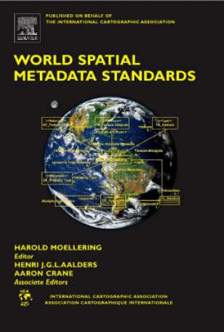
World Spatial Metadata Standards
This book represents years of work by the ICA Spatial Data Standards Commission during the 1995-2003 ICA cycles. It consists of an Introduction and six Regional Summary chapters that describe the spatial metadata activities happen ... więcej
- Język:
 Angielski
 - Oprawa: Twarda
- Liczba stron: 712
Wydawca: Elsevier Science & Technology, 2005
- Więcej informacji o książce

935.66 zł
Zwykle: 1039.69 zł
Oszczędzasz 104.03 zł
Dostępność:
50 % szansa Otrzymaliśmy informację, że książka może być ponownie dostępna. Na podstawie państwa zamówienia, postaramy się książkę sprowadzić w terminie do 6 tygodni. Gwarancja pełnego zwrotu pieniędzy, jeśli książka nie zostanie zabezpieczona.
Przeszukamy cały świat
Zobacz książki o podobnej tematyce
-

I Wrote a Book about You
74.08 zł -8 % -

Functional Programming in Kotlin
228.18 zł -5 % -

Historical and Current Perspectives on Stress and Health
937.57 zł -

Ordinary Women, Extraordinary Lives
749.03 zł
Bon podarunkowy: Radość gwarantowana
- Podaruj bon o dowolnej wartości, a my się zajmiemy resztą.
- Bon podarunkowy dotyczy całej naszej oferty.
- Możesz wydrukować elektroniczny bon z e-maila a następnie przekazać go obdarowanemu.
- Ważność bonu wynosi 12 miesięcy od daty wystawienia.
Powiadomienie o dostępności
Wpisz swój adres e-mail, aby otrzymać od nas powiadomienie,
gdy książka będzie dostępna. Proste, prawda?
Więcej informacji o World Spatial Metadata Standards
Za ten zakup dostaniesz 547 punkty
 Opis
Opis
This book represents years of work by the ICA Spatial Data Standards Commission during the 1995-2003 ICA cycles. It consists of an Introduction and six Regional Summary chapters that describe the spatial metadata activities happening in Europe, North America, Asia/Pacific, Latin America, Africa/Middle East, and the ISO community. These chapters provide the broader context and description of the milieu in which these standards operate, so that the reader can more easily understand the scientific and technical framework from whence a particular standard has emerged. The third section is a complete listing of all of the three levels of scientific and technical characteristics, and their meaning by the inclusion of a set of definitions for metadata terms used in the book. The fourth section, and by far the largest, contains 22 chapters that assess each of the major national and international spatial metadata standards in the world, and also contains a few representative subject matter profile derived from a major standard. They have been carried out in terms of all three levels of characteristics. Each assessment has been carried out by a Commission member who has been an active participant in the development of the standard being assessed in the native language of that standard. The fifth section contains a summary cross-table wall size summary chart that includes all 22 standards and profiles that are cross tabulated by 70 of the crucial characteristics. The columns provide a thumbnail sketch of each individual standard, while the rows facilitate a quick comparison of individual critical characteristics across all of the 22 standards and profiles. Many readers of our previous book have begun their standards evaluation process with this cross-table. This current book on spatial metadata standards has been purposely designed to serve as a companion working volume to the 1997 book the Commission published on "Spatial Data Transfer Standards", Moellering & Hogan, Editors, ISBN 008042433. This book assesses the National and International Spatial Metadata Standards & Profiles in their native languages, and then reports the analysis in a scientifically consistent manner in a widely used scientific language (English). It provides a summary Crosstable of the 22 Spatial Metadata Standards/Profiles in a large wall-sized table highlighting 70 of the most important scientific characteristics. It also provides the scientific and technical detail for each of the 22 Standards/Profiles to 12 primary levels, 58 second levels, and about 278 tertiary levels. Scientific and technical characteristics can be used for a wide variety of uses with spatial metadata and associated standards.
 Szczegóły książki
Kategoria Książki po angielsku Earth sciences, geography, environment, planning Geography Cartography, map-making & projections
935.66 zł
- Pełny tytuł: World Spatial Metadata Standards
- Podtytuł: Scientific and Technical Characteristics, and Full Descriptions with Crosstable
- Język:
 Angielski
 - Oprawa: Twarda
- Liczba stron: 712
- EAN: 9780080439495
- ISBN: 0080439497
- ID: 04490830
- Wydawca: Elsevier Science & Technology
- Waga: 1497 g
- Wymiary: 240 × 165 × 37 mm
- Data wydania: 08. November 2005
Ulubione w innej kategorii
-

World of Gerard Mercator
53.70 zł -

How to Lie with Maps, Third Edition
113.44 zł -

Sky Atlas
115.84 zł -23 % -

Minard System
207.20 zł -23 % -

Glasgow: Mapping the City
190.03 zł -7 % -

How to Draw a Map
79.20 zł -23 % -

Landmarks in Mapping
894.90 zł -

GIS
301.77 zł -10 % -

Art and Optics in the Hereford Map
314.92 zł -10 % -

Sad Topographies
170.36 zł -

Cartographer's Toolkit
296.35 zł -

Mapping Antarctica
270.35 zł -

Handbook of Cartography
599.94 zł -

Map Addict
50.59 zł -24 % -

Under the Map of Germany
355.48 zł -

Map Functions
780.35 zł -

Mapping New York
120.46 zł -4 % -

Mapping Latin America
275.07 zł -

Renaissance Galway
73.58 zł -

Service-Oriented Mapping
916.18 zł -

Manchester: Mapping the City
153.59 zł -14 % -

Handbook of Research on Geospatial Science and Technologies
1819.52 zł -

Mapping New Jersey
196.76 zł -

Decolonizing the Map
344.24 zł -

Cartographic Turn - Mapping and the Spatial Challenge in Social Sciences
437.81 zł -

History of Cartography
1347.47 zł -

Gijsbert Franco Baron Von Derfelden Van Hinderstein, 1783-1857
1341.65 zł -

Mapping
198.47 zł -

Computer Applications in Geography
1009.95 zł -

Advances in Cartography and GIScience. Volume 2
974.71 zł -

Mapper of Mountains
184.11 zł -9 % -

Datums and Map Projections
256.50 zł -4 % -

Cartographic Science
805.65 zł -

History of Cartography, Volume 1
1906.96 zł -

Essays on the Sociology of Perception
294.95 zł -

Commerce of Cartography
270.95 zł -

Mapping It Out
115.44 zł -23 % -

Routledge Handbook of Mapping and Cartography
1639.32 zł -

GIS and Cartographic Modeling
292.54 zł -5 % -

Multimedia Cartography
1118.17 zł -

Fuzzy Surfaces in GIS and Geographical Analysis
1014.07 zł -

Future Satellite Gravimetry and Earth Dynamics
562.70 zł -

Cartography - Maps Connecting the World
865.68 zł -

Cartography from Pole to Pole
865.68 zł -

Multimedia Cartography
1118.17 zł -

Mapping Environmental Issues in the City
865.68 zł -

Mapping Upper Canada, 1780-1867
1059.54 zł -5 % -

Thematic Cartography for the Society
562.70 zł -

Cartophilia
244.85 zł
zadowolonych klientów
Od roku 2008 obsłużyliśmy wielu miłośników książek, ale dla nas każdy był tym wyjątkowym.
Copyright! ©2008-24 libristo.pl Wszelkie prawa zastrzeżonePrywatnieCookies


 21 milionów książek
 Dostawa 10.99 zł
 (32) 444 93 66 (8-15.30h)