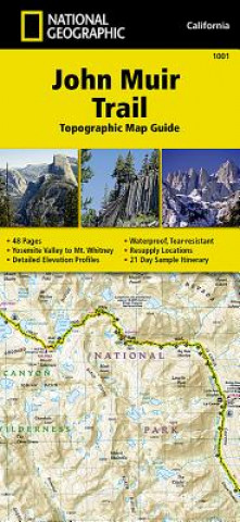
Kod: 09241560
John Muir Trail (topographic Map Guide)
Autor National Geographic Maps
National Geographic's Map Guide of the John Muir Trail is an indispensable tool for navigating one of the most famous trails in the United States. The maps start at the northern terminus in Yosemite Valley and progress along the r ... więcej
- Język:
 Angielski
 - Oprawa: Mapa
- Liczba stron: 1
Wydawca: National Geographic Maps, 2014
- Więcej informacji o produkcie

72.93 zł
Zwykle: 91.08 zł
Oszczędzasz 18.15 zł

Dostępna u dostawcy
Wysyłamy za 3 - 5 dni
Zobacz książki o podobnej tematyce
-

English File Upper Intermediate Teacher's Book with Teacher's Resource Center (4th)
167.46 zł -1 % -

Spice and Wolf, Vol. 4 (manga)
57.35 zł -5 % -

The Tour of Mont Blanc: Complete Two-Way Trekking Guide
83.68 zł -23 % -

Pacific Crest Trail
79.05 zł -23 % -

Let's Eat Italy!
238.29 zł -11 % -

Trekking the Kungsleden
79.05 zł -27 % -

Mortal Instruments 1: City of Bones
42.59 zł -23 % -

Pacific Crest Trail, Boxed
76.14 zł -15 % -

Vivian Maier: The Color Work
275.96 zł -23 % -

Beautiful Creatures Complete Paperback Collection
232.66 zł -15 % -

Astrology Magick
70.21 zł -23 % -

Everest Base Camp, Nepal
65.19 zł -5 % -

Flower Petals Inspiration Cards: Blossoming Guidance from the Garden
54.24 zł -9 % -

Themed Lesson Plans for Riding Instructors
82.47 zł -15 % -

Small Spaces
73.23 zł -5 % -

Earth from the Air
403.04 zł -

Bloggers 1
13.85 zł -18 % -

Cash Nexus
79.26 zł -23 % -

Plan & Go - John Muir Trail: All you need to know to complete one of the world's greatest trails
77.25 zł -

Drawing Type
220.81 zł -
John Muir Trail
79.05 zł -23 %
Bon podarunkowy: Radość gwarantowana
- Podaruj bon o dowolnej wartości, a my się zajmiemy resztą.
- Bon podarunkowy dotyczy całej naszej oferty.
- Możesz wydrukować elektroniczny bon z e-maila a następnie przekazać go obdarowanemu.
- Ważność bonu wynosi 12 miesięcy od daty wystawienia.
Więcej informacji o John Muir Trail (topographic Map Guide)
Za ten zakup dostaniesz 43 punkty
 Opis
Opis
National Geographic's Map Guide of the John Muir Trail is an indispensable tool for navigating one of the most famous trails in the United States. The maps start at the northern terminus in Yosemite Valley and progress along the ridge of the Sierra Nevada, past Devils Postpile, and end at the highest point in the lower 48 on the top of Mount Whitney. Along the way you will pass through; Yosemite National Park, Ansel Adams Wilderness, Devils Postpile National Monument, John Muir Wilderness, Kings Canyon National Park, and finally, Sequoia National Park & Mt Whitney.
 Szczegóły książki
Kategoria Książki po angielsku Lifestyle, sport & leisure Travel & holiday Travel maps & atlases
72.93 zł
- Pełny tytuł: John Muir Trail (topographic Map Guide)
- Podtytuł: National Geographic California
- Autor: National Geographic Maps
- Język:
 Angielski
 - Oprawa: Mapa
- Liczba stron: 1
- EAN: 9781566956895
- ISBN: 1566956897
- ID: 09241560
- Wydawca: National Geographic Maps
- Waga: 92 g
- Wymiary: 109 × 238 × 5 mm
- Data wydania: 26. September 2014
Ulubione w innej kategorii
-

Österreich, Autoatlas 1:150.000, freytag & berndt
94.63 zł -18 % -

Burgenland, Straßen- und Freizeitkarte 1:150.000, freytag & berndt
45.90 zł -18 % -

Lonely Planet Scotland Planning Map
28.62 zł -5 % -

Lonely Planet Africa Planning Map
24.50 zł -23 % -

Azores, Special Places of Excursion Road Map 1:50 000
53.94 zł -5 % -

Camino de Santiago: Camino Frances
79.05 zł -27 % -

Deutschland, Autoatlas 1:200.000, 2024/2025, freytag & berndt
59.77 zł -18 % -

Albanien, Straßen- und Freizeitkarte 1:150.000, freytag & berndt
53.94 zł -5 % -

Tokyo- Michelin City Map Laminated 9219
53.54 zł -7 % -

Evia
36.66 zł -4 % -

Gibraltar
88.70 zł -

Lonely Planet Sydney City Map
24.50 zł -23 % -

Lonely Planet Washington DC City Map
43.99 zł -11 % -

Malt Whisky Map of Scotland
38.17 zł -23 % -

Transit Maps of the World
149.28 zł -5 % -

Israel
72.93 zł -19 % -

Annapurna, Nepal
72.93 zł -19 % -

Lanzarote Marco Polo Holiday Map
29.12 zł -23 % -

Uzbekistan
58.36 zł -5 % -

New York - Michelin City Map 9204
45.20 zł -5 % -

Slowenien - Kroatien - Bosnien-Herzegowina, Straßenkarte 1:500.000, freytag & berndt
45.90 zł -18 % -

Neuer Straßenatlas Deutschland/Europa 2024/2025
28.92 zł -10 % -

Namibia
65.19 zł -5 % -

Ben Nevis and Fort William, the Mamores and the Grey Corries, Kinlochleven and Spean Bridge
58.76 zł -26 % -

Vienna City Atlas 1:12,500 scale
55.65 zł -18 % -

Cinque Terre - Portofino Hiking + Leisure Map 1:50 000
41.58 zł -18 % -

Italien Nord, Straßenkarte 1:500.000, freytag & berndt
53.94 zł -5 % -

Niederösterreich, Straßen- und Freizeitkarte 1:150.000, freytag & berndt
45.90 zł -18 % -
Carte de randonnées Alpes Vanoise. Hiking Map Alps Vanoise
63.98 zł -

Glen Coe
58.76 zł -26 % -

Loch Lomond North, Tyndrum, Crianlarich & Arrochar
58.76 zł -26 % -

Ardnamurchan, Moidart, Sunart and Loch Shiel
58.76 zł -26 % -

ADFC-Regionalkarte Bodensee, 1:50.000, reiß- und wetterfest, mit kostenlosem GPS-Download der Touren via BVA-website oder Karten-App
46.40 zł -4 % -

Zurich
66.90 zł -

Österreich Strassenkarte 1:500 000
53.03 zł -6 % -

Hong Kong & Macau Travel Map Sixth Edition
39.87 zł -4 % -

Karpathos Kasos
34.45 zł -5 % -

Pocket Atlas of Remote Islands
101.66 zł -15 % -

Morocco - Michelin National Map 742
65.19 zł -7 % -

Lonely Planet Europe Planning Map
33.54 zł -23 % -

Peru
65.19 zł -5 % -

Lonely Planet London City Map
43.99 zł -11 % -

Lonely Planet Tokyo City Map
43.99 zł -11 % -

Lonely Planet South America Planning Map
24.50 zł -23 % -

Vintage Maps Kalender 2024 - 30x30
24 zł -30 % -

Mountaineering in the Swiss Alps
77.35 zł -15 % -

Biker Atlas EUROPA 2024
62.18 zł -4 % -
West Highland Way Map Booklet
45.50 zł -23 % -

Tenerife Hikers Maps
51.83 zł -23 %
zadowolonych klientów
Od roku 2008 obsłużyliśmy wielu miłośników książek, ale dla nas każdy był tym wyjątkowym.
Copyright! ©2008-24 libristo.pl Wszelkie prawa zastrzeżonePrywatnieCookies


 21 milionów książek
 Dostawa 10.99 zł
 (32) 444 93 66 (8-15.30h)