

 Jak kupować
Dostawa
Doradca ds. zakupów
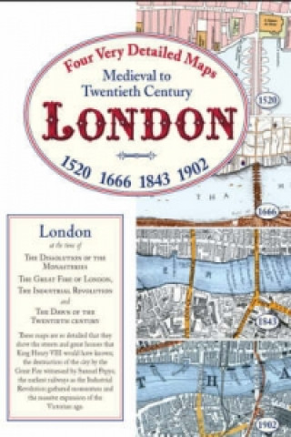
Medieval to Twentieth Century London
 Angielski
Mogłoby Cię także zainteresować


These four detailed coloured street maps illustrate the story of London from King Henry VIII to the dawn of the Twentieth Century. During this time the capital developed unlike any other in the world. The 1520 map shows the city just beginning to break out from the confines of the Roman Wall that had more or less defined its limits for 1300 years. Ribbon development was stretching out along Fletestrete and Holbourne across open countryside towards the quite separate city of Westminster. Growth continued apace but on 2 September 1666 disaster struck and most of the area within the walls and more outside was swept away in the Great Fire. The second map in this collection, commissioned by the Lord Mayor to assess the damage and to plan the redevelopment, shows the principal buildings that were destroyed many of which, including St Paul's Cathedral, were soon to be rebuilt by Sir Christopher Wren. Moving on again we find that by 1843, eighty years after the start of the Industrial Revolution the cities of London and Westminster are joined but there were still orchards and market gardens in Chelsea and the Isle of Dogs is marshy ground well below the high water mark. This map was drawn for the benefit of Hansom cab passengers. When the long Victorian age finally ended we see a London in 1902 stretching in all directions both north and south of the river with industries, docks, main line and underground railways and, near the centre, bearing witness to the origins of the greatest city in the world, the unmistakable pattern of streets that once ran alongside the Roman wall where it all began many centuries before. Each of the four maps is accompanied by a booklet describing life in London at the time.
Informacje o książce
Angielski
