
 Kontakt
 Jak kupować
Dostawa
Doradca ds. zakupów
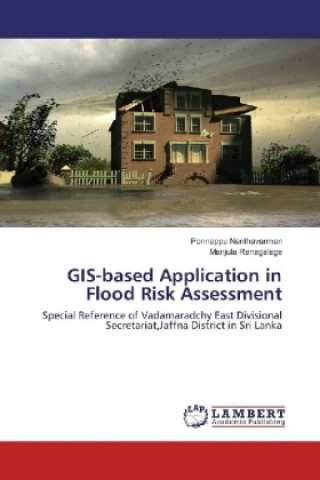
GIS-based Application in Flood Risk Assessment
Special Reference of Vadamaradchy East Divisional Secretariat,Jaffna District in Sri Lanka
 Angielski
 78 b
78 b
Nawet do 30 dni na zwrot
Klienci kupili także




 /
/
 Miękka
 47.91
zł
47.91
zł




 /
Miękka
375.30
zł
/
Miękka
375.30
zł


This book presented a geospatial information contributes to disaster and risk management (DRM) practice and clearly explain how to use GIS & secondary data for flood hazard, Flood Vulnerability, Capacity, and Flood Risk Assessment. Study area divided into High, Medium and low-risk area based on flood risk level. This book proposes an innovative method for determining economic value. A systematic analysis of a questionnaire designed for this purpose provides a template to chart the economic value of one geospatial information product, by applying a 'Cost Avoidance Approach.' Study area which affects as multi-hazards in annually is selected to illustrate the application of this valuation method. This book clearly explains how to use and analysed risk compared with marginalized community distribution such as children, women, senior citizens, disabled people, and women headed families with the interconnection of population density. The findings illustrate the steps needed for valuation assessment, which has a high potential for future research on the added value of geospatial information products in DRM.


Informacje o książce
Angielski

Podaruj tę książkę jeszcze dziś
To łatwe
1 Dodaj książkę do koszyka i wybierz „dostarczyć jako prezent” 2 W odpowiedzi wyślemy Ci bon 3 Książka dotrze na adres obdarowanegoMogłoby Cię także zainteresować









Cześć! Jestem Libroamiko, Twój doradca książkowy.
Jak mogę Ci pomóc?