Kod: 06841384
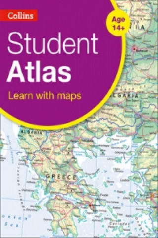
Collins Student Atlas
Autor Collins Maps
Completely new and extended edition of the best-selling Collins Student Atlas. Created specifically for Key Stage 4 students, and a vital tool for all students. Collins Student Atlas (Fifth edition), has been specifically designed ... więcej
- Język:
 Angielski
 - Oprawa: Miękka
- Liczba stron: 208
Wydawca: Collins, 2015
- Więcej informacji o książce

90.25 zł
Zwykle: 90.30 zł
Oszczędzasz 0.05 zł
Dostępność:
50 % szansa Otrzymaliśmy informację, że książka może być ponownie dostępna. Na podstawie państwa zamówienia, postaramy się książkę sprowadzić w terminie do 6 tygodni. Gwarancja pełnego zwrotu pieniędzy, jeśli książka nie zostanie zabezpieczona.
Przeszukamy cały świat
Zobacz książki o podobnej tematyce
Bon podarunkowy: Radość gwarantowana
- Podaruj bon o dowolnej wartości, a my się zajmiemy resztą.
- Bon podarunkowy dotyczy całej naszej oferty.
- Możesz wydrukować elektroniczny bon z e-maila a następnie przekazać go obdarowanemu.
- Ważność bonu wynosi 12 miesięcy od daty wystawienia.
Powiadomienie o dostępności
Wpisz swój adres e-mail, aby otrzymać od nas powiadomienie,
gdy książka będzie dostępna. Proste, prawda?
Więcej informacji o Collins Student Atlas
Za ten zakup dostaniesz 53 punkty
 Opis
Opis
Completely new and extended edition of the best-selling Collins Student Atlas. Created specifically for Key Stage 4 students, and a vital tool for all students. Collins Student Atlas (Fifth edition), has been specifically designed for students aged 14-16 years, however its well-researched uncluttered design makes it suitable for all students. This fifth edition has been extensively revised, updated and extended. It features up-to-date reference and thematic mapping, mapping skills, country-by-country statistics and a fully comprehensive index to all names appearing on reference maps. Thematic maps and accompanying graphs and tables adhere strictly to the National Curriculum guidelines and cover topics such as Tourism, Telecommunications, Environmental and socio-economic topics. All maps have been fully updated using the latest statistical information available. The inclusion of a selective list of web addresses on each thematic page ensures students are motivated to explore more deeply into a topic. High quality satellite imagery, which has been selectively used within special topic or study areas, supports data on the maps and is used to illustrate key environmental issues. Extensive lists of statistics for demographic and socio-economic facts provide up-to-date data for students wishing to create their own graphs to support individual geography, tourism, mathematics, economics or IT projects. New features * Development indicators * Pollution hotspots in the Mediterranean Sea * Urban pollution in Italy * World Agriculture * World Urbanization * World Climate Change * Low and Middle Economic Developing Countries * Ecological footprint
 Szczegóły książki
Kategoria Książki po angielsku Children's, Teenage & educational Reference material (Children's / Teenage) Atlases & maps (Children’s/Teenage)
90.25 zł
- Pełny tytuł: Collins Student Atlas
- Autor: Collins Maps
- Język:
 Angielski
 - Oprawa: Miękka
- Liczba stron: 208
- EAN: 9780007591381
- ISBN: 0007591381
- ID: 06841384
- Wydawca: Collins
- Waga: 694 g
- Wymiary: 227 × 312 × 7 mm
- Data wydania: 12. February 2015
Ulubione w innej kategorii
-

Big Book of the UK
70.41 zł -23 % -

50 States
93.17 zł -23 % -

Big Picture Atlas
70.41 zł -23 % -
National Geographic Kids U.S. Atlas 2020
57.71 zł -5 % -

Maps
114.33 zł -15 % -
Maps Poster Book
61.14 zł -23 % -
Philip's Modern School Atlas
85.01 zł -
Maps Activity Book
47.34 zł -23 % -

Children's Picture Atlas
47.34 zł -23 % -

National Geographic Kids Ultimate Globetrotting World Atlas
47.34 zł -23 % -

Oxford School Atlas
56.50 zł -23 % -

Travel Book
133.77 zł -

Oxford Student Atlas
74.84 zł -23 % -

Oxford School Atlas
61.14 zł -23 % -

Children's Wall Map of the United Kingdom and Ireland
29 zł -23 % -

Oxford Very First Atlas
33.64 zł -23 % -

Usborne Illustrated Atlas of Britain and Ireland
70.41 zł -23 % -
National Geographic Kids World Atlas
84.11 zł -23 % -

Oxford Student Atlas 2012
74.84 zł -23 % -

Oxford International First Atlas (2011)
59.22 zł -
Maps Special Edition
188.98 zł -

Barefoot Books World Atlas
70.41 zł -23 % -

Oxford International First Atlas Activity Book
33.94 zł -

Children's Illustrated World Atlas
70.41 zł -23 % -

National Geographic Student World Atlas Fourth Edition
45.62 zł -

National Geographic Kids Beginner's World Atlas, 3rd Edition
56.81 zł -

C48 First Atlas Book
55.09 zł -37 % -

Atlas of the World Picture Book
56.81 zł -

Washington DC Children's Map
22.15 zł -13 % -

Guy Fox Maps for Children
22.15 zł -13 % -

First Animal Picture Atlas
61.14 zł -23 % -

Map of Europe
93.07 zł -15 % -

World Atlas
66.78 zł -

My Pop-up World Atlas
83.60 zł -

Our World
63.56 zł -

First Atlas
81.69 zł -

Atlas of Ocean Adventures
93.37 zł -23 % -

Lonely Planet Kids My Family Travel Map - Europe
90.96 zł -

Oxford Primary Atlas
51.87 zł -23 % -

Oxford First Atlas
47.34 zł -23 % -
National Geographic Kids U.S. Atlas 2020
85.62 zł -5 % -

Beginner's U.S. Atlas 2020
61.14 zł -23 % -

Picture Atlas
29 zł -23 % -

Lonely Planet Kids Amazing World Atlas
70.41 zł -23 % -

Illustrated Atlas of India
98.71 zł -

Children's World Atlas
81.69 zł -

The Kingfisher Atlas of World History
110.40 zł -

National Geographic Little Kids First Big Book of the World
146.06 zł -

First Picture Atlas
51.97 zł
zadowolonych klientów
Od roku 2008 obsłużyliśmy wielu miłośników książek, ale dla nas każdy był tym wyjątkowym.
Copyright! ©2008-24 libristo.pl Wszelkie prawa zastrzeżonePrywatnieCookies


 21 milionów książek
 Dostawa 10.99 zł
 (32) 444 93 66 (8-15.30h)